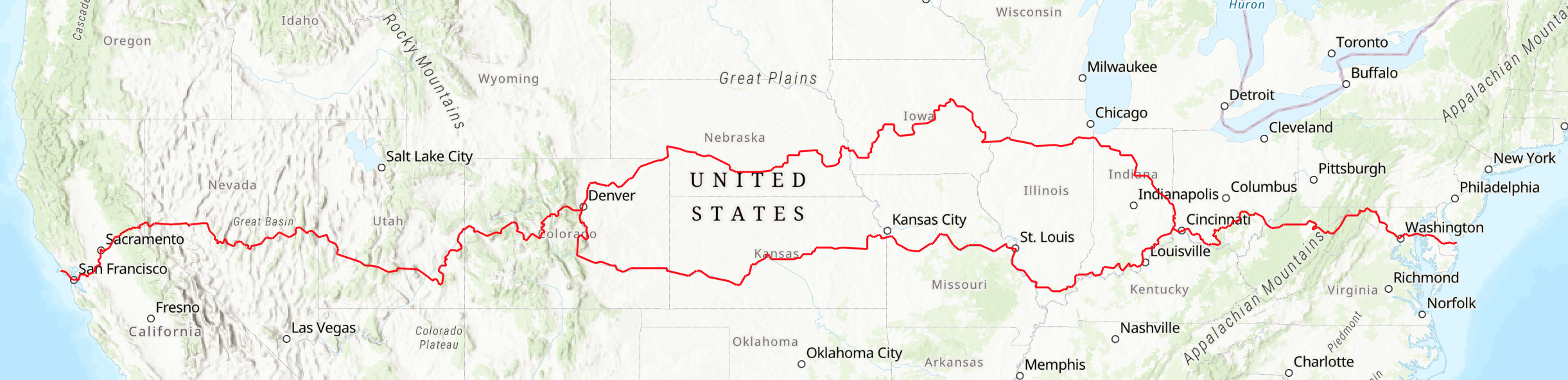
The Western States
Colorado, Utah, Nevada and California
The Western Region of the American Discovery Trail crosses the Rocky Mountains of Colorado as well as countless other ranges, red rock country, and deserts on its way to the Pacific Ocean. This segment spans four states: Western Colorado (495 miles), Utah (593 miles), Nevada (515 miles), and California (387 miles). Each section is detailed further below.
Between Denver and Point Reyes National Seashore in California, the 1,990-mile route includes mountains, deserts, and agricultural area, from the high passes of Colorado to the Central Valley of California. This region has a mixture of beauty and danger. The towering Rocky Mountains provide magnificent backcountry travel on trails that rise above timberline to reveal breathtaking views with numerous mountain passes over 9,000 feet high including four that are above 12,000 feet. In Colorado, the route crosses the Continental Divide three times.
In this part of the country, weather conditions can change suddenly, with hypothermia at higher altitudes possible in any of the 12 months. In the desert, users must guard against dehydration and heat exhaustion. The ADT route requires backpacking and camping in remote areas. With advance notice, ADT trail angels may be able to cache water for you in some areas. Some portions of the trail prohibit bicycles, and some terrain is unsafe for bicycles. The ADT Society is a source for advice on alternate routes to suit your particular mode of travel and capabilities.
Landmarks along the way include the highest point on the ADT at Argentine Pass, Colorado’s Grand Mesa (which locals call the largest flat-topped mountain in the world), Utah’s Boulder Mountain (which locals call the largest flat-topped mountain in the world), Canyonlands National Park, Capitol Reef National Park, the Great Basin, mountains topping 10,000 feet in Nevada, Lake Tahoe, the Sierra Nevada, and the Golden Gate Bridge.
The route is open for hiking, bicycling and other uses permitted by local regulations. The turn-by-turn directions provide alternate routes for bikers that avoid hiking trails not suitable for bikes as well as the federally designated wilderness areas which are closed to bikes. This summary information about the trail is not the definitive detailed description, but rather an overview. It should not be used by travelers as the sole source of route information.
The ADT Society has an in-state local coordinator for each of these states. These volunteers are willing to assist hikers, runners, bikers, and other outdoor enthusiasts with the planning of their time on the American Discovery Trail. You can find their contact details on this page.
Western Colorado
The ADT trail in Western Colorado travels about 494 miles of backcountry trails and rural roads, with several segments on larger roads. The trail begins at one mile above sea level and crosses multiple high altitude passes and also includes small valley towns along the way.
East Mountain Segment (Denver to Winfield) – 213 miles
In this segment, the trail starts at 5,317 feet and climbs through the foothills of the Rockies into the high alpine country to cross seven passes. The highest point is the Argentine Pass (13,207 feet) on the Continental Divide. The trail follows the Continental Divide National Scenic Trail for nine miles from Webster Pass to Georgia Pass, crossing the summits of four peaks over 12,000 feet high. From Georgia Pass our route then follows the Colorado Trail for 106 miles, passing through the Holy Cross Wilderness Area. As noted above, the trail crosses high mountain passes and ridges where it can snow any day of the year. In terms of discovering American culture, there’s the Georgetown National Historic District and Leadville - the highest incorporated city in the country.
West Mountain Segment (Winfield to Redstone) – 96 miles
This segment features some of the most spectacular and breathtaking views of the Rocky Mountains. From Winfield it is concurrent with the Continental Divide Trail for 16 miles, passing near the ghost towns of Vicksburg and Winfield before entering the Collegiate Peaks Wilderness Area. The ADT then climbs past Lake Ann to cross the Continental Divide and descend into spectacular Taylor Park. The route climbs to the Continental Divide at Taylor Pass (11,929 feet) before descending down East Brush Creek to historic Crested Butte, “Mountain Bike Capital of the World.” Then the ADT climbs over Paradise Pass (11,250 feet) and Schofield Pass (10,707 feet) before descending the beautiful Crystal Creek Canyon to Marble and Redstone.
West Segment (Redstone to Utah) – 185 miles
From Redstone at 7,192 feet, the ADT reaches elevations of 10,380 feet (near Twin Peaks), 10,668 feet (The Flat Tops), and 11,159 feet (Crags Crest) before plunging down into the Grand Valley to a low of 4,430 feet at Salt Creek Bridge. This segment features some of the most scenic backcountry in the world in the White River and Grand Mesa national forests, the spectacular Colorado National Monument, and the challenging Kokopelli’s Trail in desert conditions. This segment of the ADT includes more than 70 miles of rough remote uninhabited backcountry (no houses, phones, food, treated water, or shelter).
If you do 494 miles in Western Colorado, you have done about 10% of the coast-to-coast trail.
Utah
The 593 miles in Utah are some of the most rugged on the entire ADT. Utah, the Beehive State, is a land of stark environmental contrasts, and those following the route of the American Discovery Trail will get to experience much of this variety. Utah is home to many Native American tribes, and the early European settlers were Spanish who came up from Mexico in 1776. In addition to seeing amazing nature, ADT travelers also will experience old mining towns and some beautiful public lands and national parks.
The trail’s eastern part is in red rock country on the Kokopelli Mountain Bike Trail, along the Colorado River, and through Canyonlands National Park. South of Canyonlands you ascend into the high forests of Manti-La Sal National Forest, a relief from the arid desert, before descending again to the Colorado River and crossing its only bridge in southern Utah at Hite. Next come the magnificent Henry Mountains with incredible views from the top over surrounding states followed by Capitol Reef National Park. Climbing a narrow canyon out of Capitol Reef the ADT traverses the heavily forested high mountains of the Dixie and Fishlake national forests. The far western part beyond Milford brings the American Discovery Trail traveler to very dry desert conditions that require careful planning for a safe journey.
Some Specifics:
Utah/Colorado State Line to Moab (Kokopelli’s Trail) – 111 miles
The American Discovery Trail enters Utah on Kokopelli’s Trail, which starts at Loma, Colo., and winds for 146 miles through desert sandstone and shale canyons to Moab. This is red rock country where many movies and TV commercials have been filmed. Arches National Park with more than 1,800 Entrada sandstone arches is a short side trip from Moab. Moab area “slickrock” sandstone formations attract mountain bikers from around the world. The trail crosses open, uninhabited land and summer temperatures can exceed 110 degrees. The only potable water is at the Westwater Ranger Station and there is no water for the next 97 miles. Travelers need to arrange for water drops along the trail. The Colorado River is only accessible at a few points due to steep cliffs and the water is so muddy that filtering is very difficult.
Moab to Hite – 172 miles
The ADT leaves Moab, crosses Hurrah Pass, and then goes south on Lockhart Basin Trail through a treeless sagebrush desert. The trail runs along the base of towering cliffs parallel to the Colorado River and then enters Canyonlands National Park on Utah 211. The Needles region is spectacular with rock spires, arches, canyons, grabens, and potholes. From Canyonlands, the ADT crosses Beef Basin, a relatively flat 6,000-foot high plateau and then climbs Elk Ridge to elevations over 8,600 feet in the beautiful Manti-LaSal National Forest. The route then descends through Canyon Rims Recreation Area to Hite Marina in the Glen Canyon National Recreation Area. There is very little water along this 175-mile segment and water drops are required. Lingering snowpack may block the trail along Elk Ridge until June.
Hite to Boulder – 88 miles
From Hite, the ADT climbs more than 6,000 feet along North Wash and Crescent Creek to cross the Henry Mountains at Bull Creek Pass (10,485 feet). Then the trail descends across Wild Cat Mesa and enters Capitol Reef National Park, where it passes through the Waterpocket Fold. Created 65 million years ago, the Fold is a 100-mile-long ridge of vaulted white rock domes. The ADT climbs into Dixie National Forest and follows Oak Creek to the Oak Creek Campground (8,860 feet) on Utah 12. The segment ends at the trailhead for the Great Western Trail (9,580 feet) near Roundup Flat on Boulder Mountain 14 miles north of the town of Boulder.
Boulder to Circleville – 75 miles
This segment follows the Great Western Trail for 25 miles through Dixie National Forest at elevations above 9,000 feet. Then the ADT crosses the high Aquarius Plateau before plunging down to the small ranching community of Antimony at 6,439 feet. From Antimony, the trail climbs back to 9,600 feet as it crosses the Sevier Plateau near Table Mountain. The trail then descends down Rocky Ford Trail into Circleville at 6,066 feet. Circleville is the birthplace of Robert Leroy Parker, otherwise known as Butch Cassidy.
Circleville to Beaver – 29 miles
The ADT leaves Circleville and follows Birch Creek up past the Circleville Campground and into Fishlake National Forest. It climbs the south slope of the 11,000-foot Circleville Mountain massif on the Old Government Trail. The trail crosses a saddle at 9,500 feet. before following South Creek down into Beaver (5,850 feet).
Beaver to Nevada State Line – 119 miles
From Beaver the ADT climbs over Soldier Pass in the Mineral Mountains before descending to Milford at 4,957 feet. Milford is the last chance for food and supplies until you reach Baker, Nev., 97 miles away. The ADT crosses the barren and bone dry Wah Wah and Ferguson deserts which have hot days, cold nights, and sporadic sandstorms.
If you do 593 miles in Utah, you have done about 15% of the coast-to-coast trail!
Nevada
The 514-mile route through Nevada demonstrates that it is a state of extremes. It has the least rainfall of any state, one of the smallest populations, and its diverse landscape includes vast deserts and forested mountains. Nevada has over 300 named mountain ranges, making it one of the most mountainous states in the nation. More than 85% of Nevada is public land, the highest percentage in the contiguous U.S. Its mines have produced vast amounts of silver, gold, and copper. Most of its rivers drain into “sinks” without outlets where the water evaporates, leaving alkali mud flats and dry lakes. Yet, it is one of the most visited of the fifty states, thanks to Reno and Las Vegas (which are not on the ADT).
The name Nevada comes from a Spanish word meaning “snow-clad,” and it is appropriate since some of the state’s highest peaks can receive up to 225 inches of snow annually. Known as the Silver State, Nevada is also nicknamed the Sagebrush State. It is the fourteen mountain ranges and the wide sagebrush-covered valleys in between them that the traveler along the American Discovery Trail will come to know and remember best.
Detailed Trail Description
The description below is an older version, and much of it still can be followed. Since the first ADT scouting expedition in 1990, the trail been rerouted multiple times to make it more accessible and safer. The turn by turn directions and gpx files have not yet been fully updated to reflect the most recent changes. Please contact the state coordinator for up-to-date info and gpx files for Nevada.
The old route in Nevada is about 514 miles, largely on isolated, relatively unused dirt roads. There are alternate sections through wilderness areas for bikes. Vehicle support in some areas may be mandatory. Exercise extreme caution. There are long distances between water and re-supply points.
Utah State Line (Baker) to Preston — 89 miles
The ADT in Nevada begins in Baker, a small community at the base of the Snake Range, which is the home of Great Basin National Park. The most prominent peak in the park is Wheeler Peak at 13,063 feet. Great Basin offers outstanding opportunities to hike in a variety of natural habitats ranging from sagebrush desert to alpine lakes. A bristlecone pine found here was determined to be the world’s oldest living thing: 4,950 years old. Tours are given daily into the limestone and marble world of Lehman Caves with its stalactites, stalagmites, columns, flowstones, and its rare and mysterious structures called shields. The trail skirts the northern part of the park following Weaver Creek and Osceola Mine road. The route offers a view of Spring Valley, the first of several wide sagebrush-covered valleys ahead of you, and the Schell Creek Range where the trail goes through Cooper Canyon to Cave Lake State Park. The 32-acre Cave Lake is noted for its brown trout. Ely, located 15 miles north via U.S. 93, is a major resupply point for trail travelers. After crossing Steptoe Valley the route heads into the Egan Range, passing the Ward Charcoal Ovens State Historic Site where there are six massive beehive-shaped stone kilns built in 1876 to convert wood into charcoal for local mining smelters. The route across the Egan Range in Humboldt National Forest follows Water Canyon across the mountain into the White River Valley and the community of Preston. Here there is a motel, gas station, and restaurant, all outside of town on Nevada 318.
Preston to Moores Station — 88 miles
The White River Valley is wide and relatively flat, and, typical of nearly all of these valley crossings, the trail is on a seldom-traveled dirt road. The White Pine Range is crossed on an old stagecoach road along Ellison Creek. The climb to the Ellison Ranger Station takes you through a canyon with sheer rock walls and the stone wall remains of a former stagecoach stop. After reaching the pass, you enter Freeland Canyon and descend through Blackrock Canyon to Bull Spring before entering Railroad Valley. The Duckwater Shoshone Reservation is located here and is private property that the ADT crosses with permission. ADT travelers should respect the residents’ privacy. This is the greenest valley you will see in Nevada. It is fed by many springs. The Pancake Range provides a rather gentle ascent and descent just south of Brown Summit. Big Sand Springs Valley, like most of the land that is not national forest, is managed by the Bureau of Land Management. The dirt roads through this valley live up to their name: big sand. The gradual ascent into the Squaw Hills and the Confusion Hills is on a jeep road through Jumbled Rock Gulch into Hot Creek Valley and Moores Station (private property) which is a former stagecoach stop. There are a number of tall buttes and rock formations at this location. Hot Creek Valley is quite narrow. You soon begin to climb into the Hot Creek Range toward Morey Peak (10,246 feet). The ADT enters the Monitor Range on the Toiyabe National Forest and the Morey Peak and Fandango wilderness study areas where only foot and horse travel is permitted.
Moores Station to South Twin Campground — 99 miles
From Moores Station the climb is steep into Morey Canyon to Sixmile Summit near Mahogany Peak. The trail then proceeds to Cold Spring to Little Fandango to Upper Fish Lake to Little Fish Lake Valley. From the Little Fish Lake Valley ascend into the Table Mountain Wilderness through Green Monster Canyon to Mosquito Creek which descends into Monitor Valley. Look for elk, which have been reintroduced on Table Mountain. Cross the sagebrush-covered valley to Pine Creek Campground. After leaving the campground, begin a long ascent into the Alta Toquima Wilderness in the Toquima Range. The trail reaches the highest point of the ADT in Nevada near the south summit of Mount Jefferson at 11,941 feet and continues south to Jefferson Summit. From there it follows jeep roads past the historic site of Jefferson and into the Big Smoky Valley. Supplies are available in the town of Carvers. The route continues to South Twin Campground at the base of the Toiyabe Range.
South Twin Campground to Middlegate — 87 miles
The ADT follows the Toiyabe Crest National Recreation Trail across the mountain, south of Arc Dome, to the junction of Big Sawmill Creek and Little Sawmill Creek. Descend through Cow Canyon into the narrow and green Reese River Valley. The Yomba Shoshone Reservation is north of Grantsville Road where the ADT turns west, soon passing the ghost town of Grantsville. Several buildings in various stages of ruin remain as a reminder of better days when silver was mined here. Nevada has preserved the ghost town of Berlin as a state park. Silver and gold were mined here from 1895 until 1911. Today, you can be guided through the town on regular weekend tours and learn about life as it used to be in Berlin. Berlin Ichthyosaur State Park preserves the fossil remains of the 50-foot ichthyosaur, which lived here 225 million years ago when all this land was under water as a Mesozoic ocean. In Ione, the town that refuses to die (2024 population, two), you can picnic in a shaded park, refuel your car, get a meal, and down a cold beer at the Ore House Saloon & Restaurant. From Ione continue northwest on the dirt Ione Valley Road and cross Buffalo Summit in a pinyon and juniper forest. At Eastgate the road becomes paved and soon meets U.S. 50, the loneliest road in America, which you follow west for 25 miles. For most of the way along this highway the old road is still there and usable as a trail, switching back and forth on either side of the current highway. You are now also following the route of the Pony Express National Historic Trail. There is a U.S. Navy Air Base near here and low-flying aircraft are regularly seen and heard. There is a store at Middlegate.
Middlegate to Virginia City — 102 miles
The ADT continues on Highway 50 at Middlegate to Sand Springs (Sand Mountain) and then cuts straight across the dry desert. Take plenty of water. Head west across the desert for Simpson Pass, which is located between the Bunejug and Cocoon mountains. Continue across Wildcat Scarp south of the now dry Carson Lake (dry sink) and north of the White Throne Mountains. Pass the site of the Wildcat Freight Station on the Pony Express Trail. After crossing U.S. 95 where Fallon is 15 miles north, the route continues across the desert north of the Desert Mountains and south of the Dead Camel Mountains. These alkali flats are also called playa and should only be crossed when they are dry. Fort Churchill was an important military garrison in the 1860s. The remains of the adobe buildings comprising the fort are a state historical park. The American Discovery Trail follows the Carson River from Fort Churchill to U.S. 50, where it leaves the Pony Express Trail. From there the route goes up Sixmile Canyon into Virginia City, home of the famous Comstock Lode and the liveliest ghost town in the west. Once an 1870s boomtown of 30,000 people and 110 saloons, today Virginia City has thousands of visitors and each September is host to the National Championship Camel Races. Mark Twain and Brett Hart honed their writing skills here as reporters for the Territorial Enterprise.
Virginia City to California Line — 49 miles
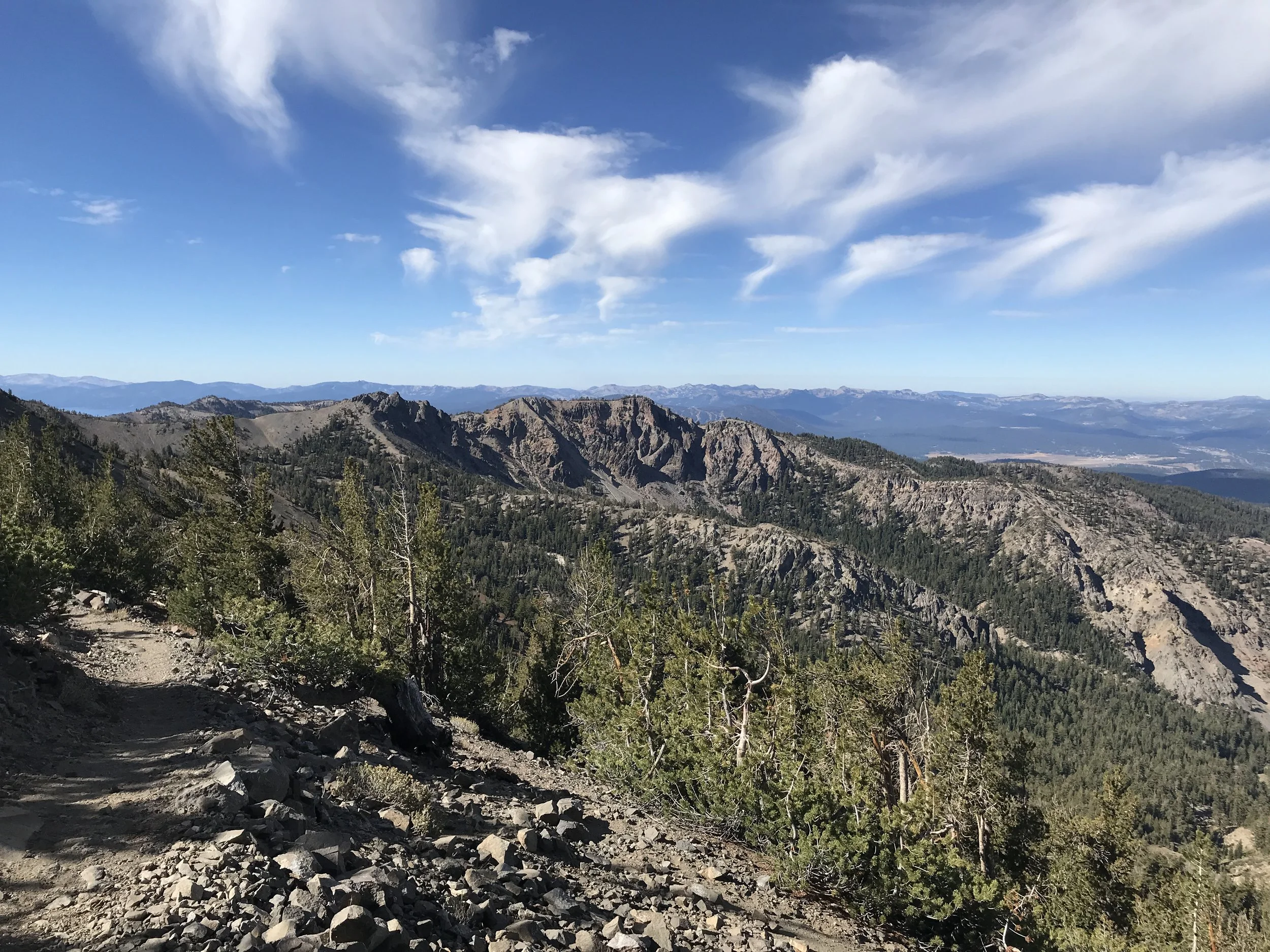
From Virginia City, the trail crosses Mount Davidson, through Washoe Lake State Park to the northern outskirts of Carson City, named in 1858 for Kit Carson. It was named the capital of Nevada when it became a state in 1864. From north of Carson City you begin a climb into the Sierra Nevada Mountains and to Tahoe Meadows. The ADT follows the Tahoe Rim Trail around the northern ridges that form the basin. The ADT continues in the Toiyabe National Forest north of Incline Village and into California.
If you do 514 miles across Nevada, you have done about 11% of the coast-to-coast trail.
California
The 387 miles of ADT in California are particularly beautiful. The American Discovery Trail enters California on the Tahoe Rim Trail on the eastern slopes of the Sierra Nevada at about 9000 feet. Lake Tahoe lies a few miles to the south and its magnificence can occasionally be seen from the trail. From Palisades Tahoe, the ADT follows the Western States Trail through the Sierra, ascending to 8,700 feet at Emigrant Pass, then descending to 1,300 feet at Auburn, along the way dropping into and climbing out of several very deep canyons. En route, the ADT follows the Pacific Crest National Scenic Trail for several miles in the Granite Chief Wilderness.
The Pioneer Express Trail and the American River Bikeway lead past Folsom Lake and along the lower American River to Sacramento. From Sacramento the ADT traverses the flat agricultural region known as the Delta before reaching Oakley. From Oakley the ADT follows a series of trails to the summit of Mt. Diablo and through the city of Walnut Creek’s open space. Trails through Briones and Tilden regional parks in the East Bay hills lead to the University of California, Berkeley, campus and onto Oakland’s urban trail system.
After crossing the San Francisco Bay by ferry, the ADT follows the Embarcadero, other bayside streets and a bicycle/pedestrian bayside trail to the Golden Gate Bridge. After the 1.7 mile bridge crossing, the ADT follows the Bay Area Ridge Trail through Marin County into the Muir Woods National Monument with its redwood stands. From here the ADT uses a series of trails to continue to the Pacific Ocean at Point Reyes National Seashore. On these trails the ADT passes along Bolinas Ridge, crosses Highway 1 and the San Andreas earthquake fault zone and finally follows the shoreline on the Coast Trail to Limantour Beach on the Pacific Ocean.
California / Nevada State Line to Highway 89 at Truckee River Bridge – 30 miles
After entering California on the Tahoe Rim Trail, the ADT follows a southwesterly course through forests and mountain meadows roughly paralleling the northwest shoreline of Lake Tahoe at a distance of several miles. An exceptionally fine panoramic view of the lake can be seen from the ADT directly south of Martis Peak. About 20 miles from the state line, the ADT leaves the Tahoe Rim Trail and follows the Western States Trail steeply downhill for several miles to the Truckee River Bridge on Highway 89. The Truckee River flows out of Lake Tahoe upstream from the Truckee River Bridge.
Highway 89 to Lewis Campground at French Meadows Reservoir - 27 miles
The ADT follows the Western States Trail most of the way through Palisades Tahoe (a major ski resort area) and climbs to the Watson Monument Immigrant Pass marker on the ridge at an elevation of 8,700 feet. Less than a mile downhill from the marker the ADT leaves the Western States Trail onto the Pacific Crest Trail. A few miles to the southeast, the ADT leaves the Pacific Crest Trail and passes through the Whiskey Creek primitive campground and Picayune Valley, passes by the Talbot and Ahart campgrounds, and ends this segment at Lewis Campground at French Meadows Reservoir.
French Meadows Reservoir to Foresthill – 43 miles
The ADT rejoins the Western States Trail a few miles west of Lewis Campground. It uses the Western States Trail through the Middle Fork of the American River watershed, which is within the Tahoe National Forest. The trail crosses tributary streams of the Middle Fork at the bottom of deep forested canyons. These are the Duncan, North Fork of the Middle Fork, Eldorado, and Volcano streams. The trail passes the historic gold-mining town sites of Last Chance and Deadwood, followed by Michigan Bluff, a historic gold mining town which today has a few residences and a couple of cemeteries. This segment ends at Foresthill, a former gold mining and lumber industry town and now a retirement community.
Foresthill to Auburn – 33 miles
The ADT descends from Foresthill on the Western States Trail to Fords Bar on the Middle Fork of the American River. The trail then follows the river downstream to the Ruck A Chucky Campground. From here the ADT leaves the Western States Trail and climbs on Drivers Flat Road to the Foresthill Loop Trail for a few miles to Foresthill Road. The road descends to the Confluence Trail, which brings the ADT to the confluence of the North and Middle forks of the American River. After rejoining the Western States Trail and crossing the American River on the No Hands Bridge, an abandoned railroad bridge, the ADT ascends to Robie Point and then to the Pacific Avenue Trailhead of the Western States Trail in Auburn.
Auburn to Sacramento at Discovery Park - 54 miles
From Auburn the ADT follows the Pioneer Express Trail downstream along the American River through its canyon and into the foothills on the northwestern side of Folsom Lake in the Folsom Lake State Recreation Area. After leaving the Pioneer Express Trail, the ADT follows the American River Bikeway. It passes Folsom Dam, Folsom Prison (which is on the other side of the river below the dam), the historic bridge across Lake Natoma to Old Town Folsom, Lake Natoma, Nimbus Dam, and the Nimbus Fish Hatchery. The ADT then continues on the American River Bikeway (also designated as the Jedediah Smith National Recreation Trail) for more than 20 miles through the American River Parkway to the end of this segment at the mouth of the American River where it flows into the Sacramento River in Discovery Park.
Sacramento to Oakley at Contra Loma Regional Park – 74 miles
From Discovery Park, the ADT crosses the American River and follows a levee trail along the Sacramento River to Old Town Sacramento. Old Town has many historic buildings and a Railroad Museum. Leaving Old Town and following city streets, the ADT passes by the magnificent historic state capitol building and the Sacramento City Cemetery, which is the resting place for many of California’s early pioneers including John Sutter Jr., the founder of the city of Sacramento and son of Captain John Sutter of gold discovery fame. Farther on, the ADT passes through South Land Park in the heart of one of Sacramento’s most beautiful residential areas. Upon leaving Sacramento, the ADT passes for over 50 miles through a flat agricultural delta area formed by the confluence of several rivers, the largest of which are the Sacramento and San Joaquin. The ADT uses levee roads for most of the way through the delta and passes through the small towns of Freeport, Clarksburg, Locke (a Chinese village dating to 1850), Walnut Grove, and Isleton.
After crossing the 1.8-mile-long bridge over the San Joaquin River from the delta area into Oakley, the ADT uses city streets for several miles to reach the trailhead for the Delta DeAnza Regional Trail on Deer Valley Road. Following this trail for a couple of miles, the ADT reaches Antioch Community Park. From here the ADT enters Contra Loma Regional Park on a trail.
Oakley to Walnut Creek at Heather Farms Park – 35 miles
A series of trails (Stewartville, Ridge, Nortonville, Black Diamond, Cumberland, Bruce Lee, Corral Road, Mitchell Canyon, Meridian Ridge, Deer Flat Creek, Prospectors Gap, North Peak, and Summit) take the ADT through the Black Diamond Mines Regional Preserve, through the city of Clayton, and up the north slope of Mt. Diablo to the 3,849-foot-high summit. From here on a clear day you can see the Central Valley of California and hundreds of miles of the Sierra Nevada beyond. Five small coal mining towns thrived in the Black Diamond area from the 1860s through the turn of the century. From Mt. Diablo, the trail follows various local trails to Heather Farms Park in the city of Walnut Creek.
Walnut Creek to Golden Gate Bridge – 48 miles
From Walnut Creek the ADT follows a series of trails which begin along the Contra Costa Canal, ascend to Lafayette Ridge, descend into Homestead Valley, skirt the shorelines of the Briones and San Pablo reservoirs and ascend to Inspiration Point. From Inspiration Point the ADT follows trails in the East Bay hills through Tilden Regional Park and Strawberry Canyon to the University of California, Berkeley, campus and then on through the city streets of Berkeley and Oakland to Jack London Square on the waterfront. Here you board a ferry for a ride across San Francisco Bay to the Ferry Building on the Embarcadero in San Francisco. The ADT follows the Embarcadero, other bayside streets, the Golden Gate Promenade, and a pedestrian trail to reach the south end of the Golden Gate Bridge while passing through Fisherman’s Wharf, Fort Mason, and the Presidio (a former elite U. S. Army base.)
The northern end of the Juan Bautista de Anza National Historic Trail is at the Presidio. Fort Point National Historic Site is located at the foot of the bridge on its south side. The fort was built by the U. S. Army in 1861. It is usually windy on the bridge, so tie everything tightly onto your pack as you cross to the north side of the bridge.
Golden Gate Bridge to Limantour Beach, Point Reyes National Seashore – 43 miles
After the bridge, the ADT follows the Coastal, SCA, Bobcat, Marinello, Miwok, and Redwood Creek trails through Marin County into Muir Woods National Monument. Muir Woods preserves one of the last remnants of the giant redwood trees that covered much of the Northern Hemisphere 140 million years ago. The mature redwoods are between 500 and 1000 years old and reach up to 250 feet in height.
The ADT leaves Muir Woods on the Stapleveldt Trail which climbs to the Pantoll Ranger Station in Mt. Tamalpais State Park. From here the ADT heads northwest on trails that offer splendid views of Stinson Beach and Bolinas Lagoon on the Pacific Ocean shoreline. The ADT then descends from the ridge, crosses Highway 1 and the San Andreas earthquake fault zone, and enters Point Reyes National Seashore. The ADT follows the Olema Valley, Stewart, Glenn, Bear Valley, and Coast trails through the national seashore to Limantour Beach, the western terminus of the American Discovery Trail.
If you do the above 387 miles in California, you have done about 7% of the coast-to-coast trail.