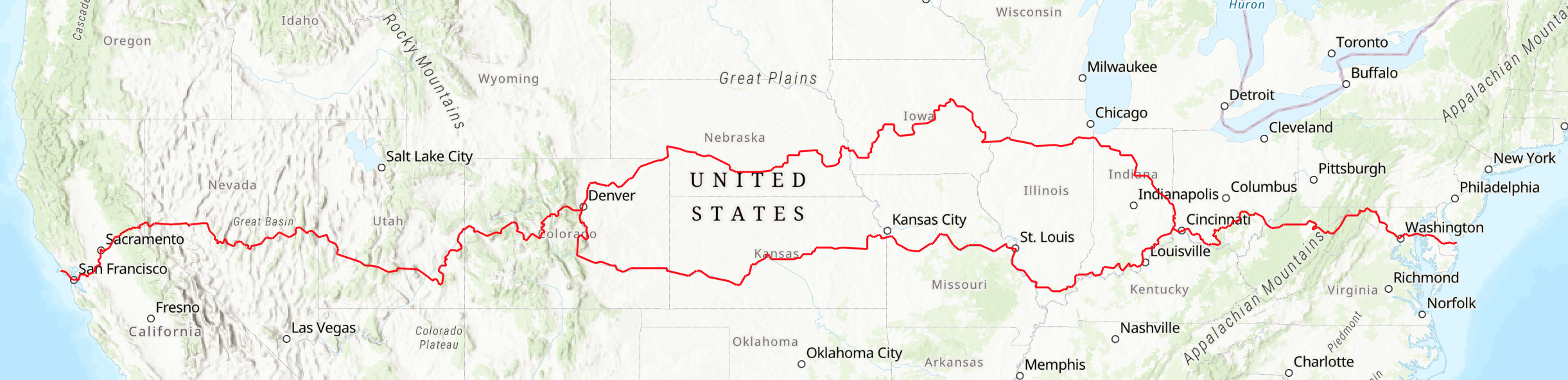

North Central Route
Western Ohio, Indiana, Illinois, Iowa, Nebraska, Eastern Colorado
The North Central Route of the American Discovery Trail connects the Great Lakes region to the Rocky Mountains. This segment spans six states, covering: Western Ohio (59 miles), Indiana (248 miles), Illinois (195 miles), Iowa (512 miles), Nebraska (543 miles), and Northeastern Colorado (241 miles). Each section is detailed further below.
The entire portion is in the Mississippi River watershed, including tributaries such as the Ohio, Wabash, Illinois, Cedar, and Platte rivers. While portions of the Midwest is fairly flat, open agricultural farmland, some segments have steep hills, and many trails are nicely shaded by trees.
Thru-travelers will have seen the state capital of Maryland; on this portion of the trail they will pass near the state capitol buildings in Iowa, Nebraska, and Colorado. Travelers will go through Chicago’s suburbs and along canal tow-paths and old railbeds. In addition there are numerous historic sites from the settlement of middle America and more recent decades. The entire route is open for hiking, bicycling, and other uses permitted by local regulations.
The American Discovery Trail Society has an in-state local coordinator for each of these states. These volunteers are willing to assist hikers, runners, bikers, and other outdoor enthusiasts with the planning of their time on the trail. You can find their contact details on this page.
This summary information is not the definitive detailed description, but rather an overview. It should not be used by travelers as the sole source of route information.
Western Ohio
The ADT North Central Route across western Ohio is 59 miles of bike trails, sidewalks and rural roads.
Elizabethtown to the Ohio / Indiana state line - 59 miles
At Elizabethtown, the route of the ADT turns north, to Miami Whitewater Forest, passing near the towns of Okeana and into Reily. The ADT passes the Governor Bebb Preserve, Bunker Hill Haven for Boys, and Indian Creek Preserve. Oxford is the home of Miami University, founded in 1809. After following trails in Hueston Woods State Park the ADT continues north on little-used country roads, going through Fairhaven and over the Harshman covered bridge to Concord Church. The trail enters Indiana near Richmond on Stateline Road.
If you do 59 miles in Western Ohio, you have done about 1% of the coast-to-coast trail.
Indiana
The 248-mile northern route in Indiana runs mostly on paved rail-banked trails and rural roads from Richmond across the Corn Belt to a more industrialized region south of Gary. The American Discovery Trail offers a diverse, interesting, and challenging route for hikers, bikers, and other trail users.
Indiana is known as the “Crossroads of America” because of the many railroad lines that crossed the state. Although Indiana’s weather ranges from cold, snowy winter days to hot and humid ones in the summer, its weather overall is considered temperate with few days being extreme. Expect showers in spring and cool, crisp, sunny days in the fall.
Ohio State Line to Marion – 86 miles
This segment includes the higher elevations in Indiana, creating a long uphill and downhill from Richmond to Muncie. The flat, glaciated topography is noted for its large grain farms, reservoirs and lakes, state parks, and wildlife areas, and the route follows many miles of greenway trails. Just south of Richmond, it follows the Whitewater River Gorge Trail as a connector to the 57-mile-long Cardinal Greenway, one of the longer private greenways in existence. The Cardinal passes through Muncie before ending at Marion, where connects to the Sweetser Switch and another greenway.
Marion to Rochester – 65 miles
The ADT follows the greenway to Sweetser and Converse and onto Bennetts Switch, where it connects to the Nickel Plate Trail, which runs northward to Rochester through the towns of Peru and Denver and onto Rochester. Peru was once the winter home of many circuses and features a fine circus museum.
Rochester to Indiana/Illinois State Line - 97 miles
The route follows the shore of Bruce Lake and passes Tippecanoe River State Park and Winamac State Fish and Wildlife Area. The Erie-Lackawanna Trail provides another greenway, with the route tying into the Pennsy Northwest Greenway to cross into Illinois at a point about 30 miles south of downtown Chicago.
If you do 248 miles in Indiana, you have done about 5% of the coast-to-coast trail.
Illinois
The trail is 195 miles in Illinois, the Prairie State, crossing a region with some of the richest soils in the world, enabling abundant crops of corn and soybeans. About 95% of the trail is on canal paths and rail trails, going across a flat and undulating region on the long-distance I&M Canal and Hennepin Canal towpaths, the Pennsy and the Old Plank Road Trail rail-trails, a forest preserve trail along historic Thorn Creek, and an urban trail across the Quad Cities.
Indiana State Line to Joliet - 39 miles
This segment showcases a diverse sampling of varied terrain: native prairie, equestrian landscapes, forest preserves, and small suburban historic downtowns with services. The Pennsy Railroad was once the largest in the U.S. Today it ‘s converted to a trail as you cross from Indiana into Illinois. Next, the Thorn Creek Trail follows Thorn Creek, which, when it drained into Lake Michigan, was used by First Americans, French voyageurs and missionaries. It connects to the Old Plank Road Trail, which was intended to be developed as a plank road but instead was acquired and developed as a railroad corridor to Joliet.
Joliet to Bureau Junction - 79 miles
In Joliet, you can visit the Old Joliet Prison. Just past Joliet, the Illinois & Michigan Canal Trail begins. A National Heritage Corridor, by linking the Great Lakes with the Illinois and Mississippi Rivers in 1848, it spurred on Chicago’s enormous growth for the next several decades, until the railroads became dominant. You’ll find historic small towns, museums, and interpretive markers along the way, usually with a great blue heron as a natural guide. In LaSalle, you can ride a mule-pulled canal boat replica or take a break at the I&M Canal Visitor Center. Past sister-city Peru, travelers follow little-used back roads for about 20 miles, with a new off-road option, the Alliance Trail, being planned by local institutions.
Bureau Junction to Iowa Line (Rock Island) - 77 miles
The Hennepin Canal State Trail provides a stunning way to travel from the Illinois River to the Mississippi River. Opened for business in 1908, the canal quickly failed because of competition from the railroads, but although it carried small loads until 1951. The state of Illinois stepped in and made it a premier component of its state park system. Most of the locks are in place, fishing is great, and camping areas abound. Several miles past Sheffield, the Hennepin Canal Visitor Center shows you the history of a bygone era of transportation. You’ve used several towpaths following the ADT since Delaware. This is the last one along the ADT route. The northern Illinois ADT ends in the Quad Cities, home of Black Hawk and his nation until driven out in the 1830s, opening Illinois up to the newer settlers. The final highlights in Illinois are the 1862 Rock Island Arsenal and its pedestrian/bike bridge over the Mississippi River.
If you do 195 miles across Illinois, you have done about 4% of the coast-to-coast trail.
Iowa
The ADT route in Iowa is 543 miles long, through a region landscaped during the Ice Ages by massive glaciers that smoothed out some of the hills and left perhaps the most fertile soil in the world. Farms take up about 90 percent of the gently rolling land, which produces more corn and beans than any other state. Iowa is also the leading manufacturer of farm and road construction machinery.
In this state, the ADT is divided into six segments. Mostly on rail-trails, it passes through numerous small towns and communities, often with buildings and architecture from 100 to 150 years ago.
Davenport to Cedar Rapids – 110 miles
The American Discovery Trail enters Iowa at Davenport and begins its journey on one of the many rail-trail projects that have made Iowa a leader in the conversion of abandoned rail rights-of-way into recreational and non-highway transportation corridors. The route through downtown Davenport is on the Riverfront Trail along the Mississippi River. Leaving Davenport, the ADT briefly follows Highway 22, through Wildcat Den State Park, to Muscatine, the town where Samuel Clemens (Mark Twain) lived and found inspiration for some of his writings. The ADT in Muscatine is on another trail along the Mississippi River before turning west, where it eventually joins the Hoover Nature Trail, a former rail line, at Conesville. Heading north through Nichols and West Liberty, this trail passes through West Branch, the birthplace of President Herbert Hoover and the site of his memorial library. The ADT continues north through Oasis, Morse, Solon, and Ely and on to the Cedar Rapids metro trail system.
Cedar Rapids to Waterloo – 61 miles
The ADT continues on a paved trail through Hiawatha to the 63-mile-long Cedar Valley Nature Trail’s southernmost point. One of our nation’s first rail-to-trail conversions, the Cedar Valley Nature Trail follows the Cedar River and is well-used by area residents, attracting many out-of-state trail users as well. The depots at Center Point and Gilbertville have been faithfully restored. The northern end of the Cedar Valley Nature Trail is across from Deerwood Park in Evansdale. The Cedar Prairie Trail takes the ADT into Waterloo, where the Cedar Valley Lakes Trail and trails in George Wyth Memorial State Park become the route. A sign in this park marks the northernmost point of the ADT.
Waterloo to Marshalltown – 79 miles
The Waterloo-Cedar Falls metro area is where the ADT turns south onto the Sergeant Road Trail to Hudson and then on farm-to-market roads to Voorhies and then west to Reinbeck. From here through Morrison to Grundy Center, the ADT is on the Pioneer Trail, another packed limestone rail-trail. Again on farm-to-market roads, the ADT heads south to Beaman, then turns west and joins the Comet Trail to Conrad, where back roads take the ADT into Marshalltown. There the ADT is on local trails, then less-traveled roads going southwest to the Heart of Iowa Trail.
Marshalltown to Des Moines – 75 miles
The Heart of Iowa Trail begins south of Marshalltown at Melbourne, continuing through Rhodes, Collins, and Maxwell, to Slater. There, after a few miles on back roads, it meets up with the Saylorville and Neal Smith trails, which take the ADT into Des Moines.
Des Moines to Atlantic – 124 miles
West of Des Moines, at Clive, the ADT becomes part of the Raccoon River Valley Trail, which winds through prairie remnants and bottomland timber areas and passes through Waukee, Adel, Redfield, Linden, and Panora to Herndon. Adel has a beautifully restored railroad depot. The ADT leaves the Raccoon River Valley Trail to go west on highway E63, which leads to Coon Rapids, home of the 4,300-acre Whiterock Conservancy along the Middle Raccoon River. There the trail turns south and then west into Audubon, where the ADT joins the T Bone Trail through Hamlin, Exira, and Brayton to Atlantic, a town of about 7,000 people.
Atlantic to Council Bluffs – 94 miles
From Atlantic, the ADT heads to Lewis and Cold Springs State Park and then west through Oak, Emerson, and Hastings. From here the trail goes south to Malvern, where it joins the Wabash Trace Trail, going through Silver City and Mineola. At Council Bluffs, which is home to the Western Historic Trails Center, the ADT crosses the Missouri River into Nebraska on the spectacular 3,000-foot-long Bob Kerrey Pedestrian Bridge.
If you do the 543 miles in Iowa, you have done about 10% of the coast-to-coast trail.
Nebraska
The ADT route in Nebraska is 516 miles long. It’s a place known as the “Historic Trails” state. The Lewis and Clark, Mormon Pioneer, Pony Express, Oregon, and California National Historic Trails all cross Nebraska. Portions of the ADT follow portions of their westward routes. The Platte River, along which many of the trails run, is the source of the name Nebraska, which in the Oto Indian language means “flat water.”
Most who rushed across the state to get to the California gold fields or to their land of promise failed to realize the riches that Nebraska held in its soil. With excellent soil conditions and plentiful water from the Missouri, Platte, and Niobrara rivers, Nebraska, for those who stayed, became the “promised land.” Corn is Nebraska’s number one agricultural crop, thus giving the state its “Cornhusker” nickname.
Omaha to Lincoln - 100 miles
The ADT enters Nebraska on the Bob Kerrey Pedestrian Bridge over the Missouri River. The bridge brings you into downtown Omaha, where the ADT follows a riverfront trail to Haworth Park in Bellevue, Nebraska’s oldest community. From there, it uses other urban trails. Omaha is Nebraska’s largest city and the birthplace of President Gerald Ford, Malcolm X, and Marlon Brando. Boys Town, the Henry Doorly Zoo, and Joslyn Art Museum are located here. Leaving the city, the ADT follows a trail parallel to Nebraska 50 to Wabash and then Lincoln. Lincoln is the capital of Nebraska, the only state to have a one-house (unicameral) legislature. The trail passes the State Capitol and Museum of Nebraska History, which houses three floors of exhibits from prehistoric times to the present.
Lincoln to Stromsburg - 70 miles
The ADT follows paved and dirt roads from Lincoln to Stromsburg, passing through or near Branched Oak State Recreation Area, David City, Shelby, and Osceola. The ADT uses the Oak Creek Trail between Valparaiso and Brainard.
Stromsburg to Doniphan - 65 miles
At Central City the ADT meets the Platte River and the Oregon National Historic Trail, which is on the south side of the river. The ADT continues on country roads to Grand Island and crosses under I-80 to Doniphan. The Stuhr Museum of the Prairie Pioneer in Grand Island has an exhibit on pioneer life and a reconstructed railroad town of the 1860s. The Pony Express National Historic Trail and the Mormon Pioneer National Historic Trail also follow the Platte River Valley.
Doniphan to Fort Kearny - 41 miles
The route stays mostly on dirt roads south of the Platte River through Denman, Lowell, and Newark to Fort Kearny State Historical Park, a government outpost established in 1848. It protected pioneers on the Oregon Trail, crews building the Union Pacific Railroad, and mail-carrying stagecoaches. The broad Platte River Valley is the site of one of the wonders of the natural world as nearly 500,000 sandhill cranes gather here from late February through early April on their spring migration northward.
Fort Kearny to Johnson Lake - 50 miles
Heading west from Fort Kearny, the ADT approximately follows the Oregon Trail through the flat land on the south side of the Platte River. The trail follows country roads through some of the best corn farms in the U.S. Just before reaching Johnson Lake, the trail climbs out of the river valley and passes through wildlife-rich canyon country along the top of the valley ridge.
Johnson Lake to Maloney Reservoir - 76 miles
From Johnson Lake State Recreation Area near Lexington the ADT follows maintenance roads along the Tri-County Supply Canal to south of North Platte. These maintenance roads are currently restricted to maintenance vehicles and foot traffic only. Towns along this section include Cozad, the location of the Robert Henri Museum, and Gothenburg, the site of a Pony Express station and the Sod House Museum. The Fort McPherson National Cemetery is west of Jeffrey Reservoir. Buffalo Bill Ranch State Historical Park is in North Platte.
Maloney Reservoir to Lake McConaughy - 62 miles
From Lake Maloney State Recreation Area, the ADT continues following the canal road system to the north shore of Sutherland Reservoir, where it passes north of I-80 and follows the Sutherland and Keith-Lincoln County canals to Lake McConaughy north of Ogallala.
Lake McConaughy to Colorado State Line - 52 miles
Near the west end of the lake, the trail enters Ash Hollow State Historical Park, which lies on an unusual geologic stratum known as the Ash Hollow formation. This is an excellent example of the landscape of the central Great Plains just before the Ice Age. Deep ruts of the Oregon Trail can be seen at Windlass Hill. The ADT heads south on county roads to Big Springs and enters Colorado near Julesburg and the intersection of Interstates 76 and 80.
If you do the above 516 miles in Nebraska, you have done about 11% of the coast-to-coast trail.
Northeastern Colorado
The ADT route from the Nebraska state line to Denver is 241 miles. The trail in Colorado, the Centennial State, offers a variety of challenges. Entering the state at the northeast corner, the ADT crosses the eastern plains of Colorado following the paths of explorers and pioneers in their wagons painted with “Pikes Peak or Bust!”. As one approaches Denver, the front range of the Rocky Mountains gradually appears larger and larger.
Northeast Segment (Nebraska to Denver) - 241 miles
From Nebraska, the ADT crosses the eastern plains of Colorado along the South Platte River, climbing from 3,448 feet to 5,280 feet — which is why Denver is known as the Mile-high City. Highlights along the way include Fort Sedgwick, Overland Trail, and Fort Vasquez museums, and the South Platte River Trail. The route mostly uses county and state roads through the pastoral countryside.
It’s If you do the 241 miles in northeast Colorado, you have done about 5% of the coast-to-coast trail. Once in Denver, travelers have a choice:
Denver to the Pacific - via the ADT Western States — 1,990 miles
Denver to the Atlantic - via the ADT Southern Route — 3,018 miles
Rest of the Heartland Loop - via the ADT Southern Route — 1,956 miles