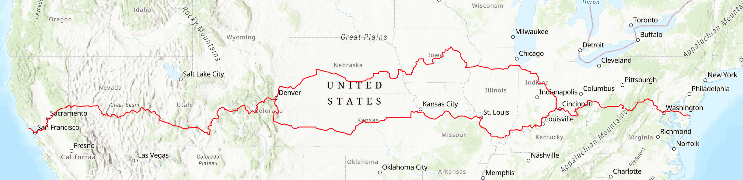
South Central Route
Indiana, Illinois, Missouri, Kansas, SE Colorado
The South Central Route of the American Discovery Trail provides a scenic and historic path across five states: Indiana (361 miles), Illinois (295 miles), Missouri (339 miles), Kansas (575 miles), and southeastern Colorado (384 miles). Details on each state's segment are provided below.
The trail’s South Central Region lies within the vast Mississippi River watershed, which includes major tributaries such as the Ohio, Wabash, Missouri, Kansas, and Arkansas.
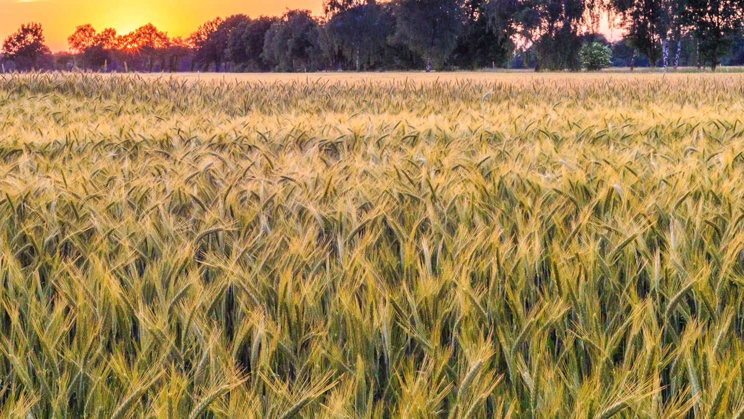
Although parts of the Midwest are known for their flat terrain, this route also features rolling hills and shaded paths, offering a diverse hiking and biking experience. The landscapes showcase distinct natural and agricultural ecosystems—more wheat fields and fewer cornfields.
The trail passes through the Colorado state capital, Denver, and comes close to both Jefferson City, Mo., and Topeka, Kan. Highlights include scenic natural areas, vibrant communities, and historic sites and landmarks from the settlement of the west.
The South Central Route of the American Discovery Trail is open for hiking, biking, and other recreational uses permitted by local jurisdictions. To assist with planning and on-the-ground support, the American Discovery Trail Society has dedicated local coordinators in each of these states. These experienced volunteers are ready to help adventurers of all types make the most of their journey on the American Discovery Trail. This summary information about the trail is not the definitive detailed description, but rather an overview. It should not be used by travelers as the sole source of route information.
Find your local state coordinator here: American Discovery Trail State Coordinators.
Indiana
The 361-mile southern route in Indiana runs along the Ohio River through Indiana’s Southern Hills region, the only part of the state not reached by the glaciers during the last Ice Age.
Elizabethtown, OH,to Clifty Falls State Park — 69 miles
The first mile of the Southern Route is from the trail junction in Elizabethtown to the Ohio/Indiana line on the appropriately named State Line Road. The ADT then follows roads through Greendale and into Lawrenceburg, an early 1800s steamboat town on the Ohio River. At Aurora, known as “River City U.S.A.,” travelers turn away from the Ohio River. Parts of the route into Farmers Retreat are on gravel roads and pass through the towns of Hartford and Milton. This section incorporates the Laugherty Creek Trail and is an official Boy Scout trail. The ADT passes through Friendship and Madison, which has the largest National Historic Landmark District in the United States, as well as Clifty Falls State Park.
Clifty Falls State Park to Deam Lake Campground - 54 miles
After passing Hanover College, Indiana’s oldest private college (1827), the trail leaves the Ohio River again and passes through Saluda and Underwood before reaching the Clark State Forest. The Knobstone Trail follows 58 miles of the north-south Knobstone Escarpment. The ADT joins the Knobstone Trail in Clark State Forest and goes south to the Deam Lake trailhead.
Deam Lake State Park to Corydon - 46 miles
From Deam Lake State Park the ADT takes back roads through Wilson and St. Joseph to New Albany, across from Louisville, Ky. In nearby Jeffersonville guided tours are available at the Hillerich and Bradsby Company, makers of the Louisville Slugger baseball bat. The ADT follows south along the river to Corydon, Indiana’s first state capital and the site of Indiana’s only Civil War battle. The route joins the 27-mile Adventure National Recreation Trail in Harrison-Crawford State Forest.
Corydon to St. Meinrad - 96 miles
The ADT again winds high above the Ohio River with great views before entering the Hoosier National Forest. Through the Hoosier the ADT is on the Mogon Ridge, Tipsaw Lake, and Two Lakes trails. The ADT is on a gravel road from Sassafras to St. Meinrad.
St. Meinrad to Evansville - 64 miles
The route then passes through Fulda and on to Santa Claus, where the Holiday Amusement Park is located. Lincoln Boyhood National Memorial preserves the farm where Abraham Lincoln lived from 1816–30. The ADT enters Lincoln State Park where the musical drama “Young Abe Lincoln” can be enjoyed. The ADT is on gravel roads from Gentryville through Folsomville to Boonville, where a visit to the Warrick County Museum is recommended. The ADT then heads south through Pelzer to the Hoosier Heritage Scenic Trail where the ADT is once again along the Ohio River. Angel Mounds State Historic Site is the location of the largest and best preserved prehistoric Indian mounds dating from 1200 to 1400. Through Evansville, the ADT takes Memorial Parkway, a greenbelt where there are historic monuments as well as the Evansville Museum of Art, History, and Science.
Evansville to Illinois State Line (Wabash River) - 33 miles
Leaving Evansville, the ADT is on gravel roads through Heusler to Mount Vernon and then Hovey Lake, which is a cypress swamp. The ADT then crosses the Wabash River, which marks the border between Indiana and Illinois.
If you travel this 361 miles in Indiana, you have completed approximately 8% of the coast-to-coast trail.
Southern Illinois
The ADT’s 295 miles across Southern Illinois consist of three segments, on trails, and on gravel and paved roads/shoulders. Weather in the summer can be tropical with high humidity, but winter travel is often pleasant although it can be far below freezing at times.
Indiana State Line to Intersection with the River to River Trail – 38 miles
The Southern Illinois Route crosses the Wabash River into Illinois on Illinois Route 141. Following back roads through acres and acres of farmland, the trail passes New Haven then turns south to Shawneetown and joins the River to River Trail on Karbers Ridge Road.
River to River Trail to Grand Tower – 141 miles
In this segment the ADT follows the route of the River to River Trail. Proceeding westward in rugged hills and mixed hardwoods the trail passes High Knob and is soon in the Garden of the Gods, an area of steep cliffs and huge eroded rocks that afford outstanding vistas of the surrounding hills. The trail passes through the community of Herod, then on to One Horse Gap and on to Lusk Creek Canyon National Natural Landmark before reaching the town of Eddyville. Further west is Sand Cave, the largest sandstone cave in North America, which may have been occupied by humans for about 12,000 years. The trail then passes Millstone Bluff which is a National Register site that was a Mississipian Indian village and a quarry from which pioneers dug rock for their millstones. The ADT then passes Dutchman Lake before it enters Ferne Clyffe State Park, which has many unique rock formations. The trail then passes through Panther Den which has a maze of building-size rock boulders and then moves through Crab Orchard National Wildlife Refuge before entering Giant City State Park. Farther west, travelers enter Bald Knob and Clear Springs wildernesses. After the LaRue Pine Hills, this segment ends with an 11-mile levee walk to Grand Tower.
Bicycles are not allowed on the majority of the River to River Trail or in the federal wilderness areas, so an alternative bicycle route is available. The bicycle alternative route leaves the official ADT route midway between New Haven and Shawneetown and heads west on country roads to Eldorado. In Eldorado it picks up a local bike trail to Harrisburg, where it picks up the Tunnel Hill State Rail Trail. Along the 60-mile-long Tunnel Hill trail, it passes through the namesake 800-foot-long tunnel, over numerous bridges, and through the cities of Carrier Mills, Stonefort, New Burnside, Tunnel Hill, Vienna, Belknap, and Karnak before terminating at Barkhausen Cache River Wetlands Center. After leaving the Tunnel Hill trail the route continues on 35 miles of country roads to Wolf Lake, where it then takes Illinois Highway 3 five miles north to rejoin the River to River / ADT Trail to continue on to Grand Tower.
Grand Tower to East St. Louis (Missouri State Line) – 116 miles
The ADT continues north on a combination of back roads and maintenance roads on the top of the levees along the Mississippi River to south of East St. Louis. There are several historic sites along this portion of the ADT, including Fort Kaskaskia, founded by Jesuit priests in 1703 at the site of an Indian village; Fort de Chartres, built by the French in 1750; Modoc, where a rock shelter is said to be the site of the longest continuous habitation in North America; Prairie du Rocher, first settled in 1722 as a French trading post; and Cahokia, the oldest town in Illinois settled in 1699 by French priests who established a mission here. A statue of Popeye stands in Chester, home of the creator of the cartoon character. The ADT crosses the Mississippi River into Missouri from south of East St. Louis on the Eads Bridge’s pedestrian walkway,
If you travel 295 miles across Southern Illinois, you have completed approximately 4% of the coast-to-coast trail.
Missouri

The 339 mile ADT route in Missouri is dominated by peaceful rail-trails. First claimed by the French explorer La Salle for France in 1682, the United States acquired the land that became Missouri as part of the 1803 Louisiana Purchase. Lewis and Clark began their historic expedition where the Missouri River empties into the Mississippi River just north of St. Louis. The ADT follows their route along the Missouri River from St. Charles to Boonville. The route of the ADT from Boonville to Kansas City follows the Katy Trail and Rock Island Trail from Boonville through Sedalia, Post Oak, Pleasant Hill, and into Kansas City.
St. Louis to St. Charles – 27 miles
After crossing the Mississippi River into St. Louis on the Eads Bridge with its new pedestrian walkway, the ADT immediately enters Gateway Arch National Park, which houses the Museum of Westward Expansion and is the site of the 630-foot-high Gateway Arch. The route then follows city sidewalks in an urban environment to Forest Park and crosses the Missouri River on the Discovery Bridge at St. Charles. Originally known as Les Petites Cotes (the little hills) by the French, then San Carlos by the Spanish, the town became St. Charles in 1804.
St. Charles to Boonville (Katy Trail) – 149 miles
The ADT joins the 250-mile Katy Trail in St. Charles. It follows the north bank of the Missouri River to Franklin, then crosses the river at Boonville, and goes cross-country to Clinton. This was the route of the Missouri-Kansas-Texas (MKT) Railroad, which was built in the 1870s and was affectionately known as “the Katy.” The ADT joins the Katy in Frontier Park in St. Charles. Heading west from St. Charles, the Katy passes limestone bluffs in the Weldon Springs Wildlife Area. The trail is ideal for bird watching, as it is located along the Missouri River flyway, which is used by many migrating songbirds and waterfowl. Daniel Boone lived the last 20 years of his life near Defiance, and his four-story Georgian-style home, built between 1803 and 1810, is open to visitors. The ADT passes north of Jefferson City, the capital of Missouri. Towering limestone and dolomite bluffs border the trail from here to Rocheport. American bald eagles are common along this section in winter. Hartsburg, McBaine, and Huntsdale are typical post-Civil War railroad towns. A spur of the MKT has been converted into a rail-trail that goes into downtown Columbia and the University of Missouri-Columbia. Rocheport prospered as a riverboat town before the Civil War, and a large part of the town is listed on the National Register of Historic Places. The railroad tunnel just west of Rocheport is the only tunnel on the Katy Trail.Franklin and then Boonville were where the first great wagon trains started out on the Santa Fe Trail. The first battle of the Civil War in Missouri was fought at Boonville. Boone’s Lick State Historic Site is nearby. It comprises two salt springs where Daniel Boone’s sons made salt by heating brine in large iron pots.
Boonville to Kansas City Line (state line) – 162 miles
The ADT continues on the Katy Trail from Boonville southwest to Windsor, approximately 56 miles. The ADT passes trailheads at the towns of Boonville, Pilot Grove, Clifton City, Sedalia, and Green Ridge. The ADT joins the Rock Island Spur of the Katy Trail State Park about a half mile prior to the Windsor trailhead. The route from Windsor to Pleasant Hill follows the Rock Island Spur; this rail-trail travels about 50 miles northwest across three counties. The trail passes Leeton, Chilhowee, and Medford, and ends in Pleasant Hill. From here the ADT follows a mix of paved and gravel roads into Kansas City, staying south of the Missouri River. The route travels through Lee’s Summit, Kansas City, Raytown, and back into Kansas City before connecting to the Blue River and Indian Creek trail systems. The Indian Creek Trail continues southwesterly to the Kansas state line.
If you travel the 339 miles in Missouri, you have completed approximately 8% of the coast-to-coast trail.
Kansas
The ADT route in Kansas is 575 miles. While on the ADT in Kansas, you will walk in the footsteps of the pioneers, the Great Plains Indian tribes, and many a western hero or bandit. You will see unique geological formations, follow rivers, view the gorgeous Flint Hills and Smoky Hills, and watch birds at the Cheyenne Bottoms Wildlife Refuge. Most of the route through the Sunflower State is on paved or gravel back roads. The American Discovery Trail generally follows the Santa Fe National Historic Trail for much of the way.
The central section has many streams and rivers; however, as one ventures westward, the distance between towns increases and the sources of clean water become increasingly rare. Weather can be unpredictable and can become severe very quickly. You are in “tornado alley” (during spring and summer) and the heat indices can reach 110+ degrees F (43C). Winter blizzards, especially in western Kansas, can create whiteouts with wind chills of -50 degrees F (-45C) or lower.
Leawood (MO line) to Lawrence – 54 miles
After crossing into Kansas, the route through the Kansas City metropolitan area uses low-volume roads, some with sidewalks, and a developing system of trails. One part of this route is Corporate Woods, where the trail winds between the many buildings of a business park. Many who work here walk or ride their bicycles from home. After passing Shawnee Mission Park, the trail stays south of the Kansas River and heads west through Clearview City, Eudora, and Lawrence.
Lawrence to Herington – 125 miles
At Lawrence, the ADT follows the Kansas River Levy Trail, crosses the Kansas River into downtown Lawrence, and visits Massachusetts Street, which is a popular shopping and dining destination. This part of Kansas and the next 200 miles are anything but the flat image that most folks may have in their minds. The landscape in physiographic terms is known as Osage Questas, or hill-plains with rather steep slopes, and includes the Flint Hills, where the bluestem pastureland varies from 100 to 400 feet in elevation. From Lawrence to Ottawa, the trail parallels U.S. Highway 59. Between Ottawa and Council Grove, the route uses the Flint Hills Nature Trail. The active railroad near the trail from Ottawa to Quenemo is the busiest rail line in Kansas. At one time, Council Grove was the last and most crucial outfitting post on the Santa Fe Trail. There are 12 historic sites here, including the Madonna of the Trail, a 16-foot memorial to the courage of pioneer mothers, and the Old Kaw Mission and Museum.
Herington to McPherson – 61 miles
The American Discovery Trail continues on back roads and crosses the Maxwell Game Preserve. There are herds of bison and elk and an observation tower. McPherson State Fishing Lake offers primitive camping. The first man-made diamond is on display in the McPherson Museum.
McPherson to Great Bend – 80 miles
The landscape begins to gain elevation slowly, and the hills lessen as the ADT enters the Great Plains. Kansas usually produces more wheat than any other state, which becomes very evident to the American Discovery Trail traveler. The salt mines that have been in operation since 1890 near Lyons are not so apparent. This land was occupied by the Quivira Indians, and artifacts of their sixteenth-century culture are exhibited in the Coronado-Quivira Museum. At Great Bend, the trail joins the Arkansas River and follows it to Canon City, Colorado, about 500 miles west. The towering concrete grain elevators at Great Bend signal that this is the regional grain center. It was also the area’s oil capital, and pumps still extract crude oil from underground reserves beneath the wheat fields. Fort Zarah was located here and guarded the Santa Fe Trail until 1869. South of Great Bend is Quivira National Wildlife Refuge, a birder’s paradise, where over 250 species of birds have been observed.
Great Bend to Kinsley – 63 miles
The American Discovery Trail goes north through Cheyenne Bottoms Wildlife Area, a 19,000-acre natural land sink once a favorite hunting ground for the Cheyenne Indians. Pawnee Rock State Historic Site preserves a prominent landmark on the Santa Fe Trail. The 100-foot-high red sandstone outcrop was the site of many Indian ambushes. Larned is the midway point along the Santa Fe Trail. The Santa Fe Trail Center Museum and Cultural Center is located here. Also, Fort Larned National Historic Site is one of the most complete preservations of a western fort. Fort Larned was built in 1859 to protect the mail coaches and commercial wagon trains on the Santa Fe Trail. Farther along the Arkansas River is Kinsley, once a railroad boom town but today a quieter agricultural center. Kinsley is noted for being exactly halfway (by highway, not by trail) between San Francisco and New York City, 1,561 miles from either city.
Kinsley to Dodge City – 55 miles
Dodge City was called “Hell on the Plains” and the “Wickedest Little City in America.” Its infamous Front Street was one of the wildest on the frontier, with a well-stocked saloon for every 50 residents. This is where cowboys, cattlemen, buffalo hunters, gunfighters, soldiers, and railroad men all gathered to the delight of the brothel keepers and morticians. Boot Hill got its name because so many men died with their boots on. There was a high-class side to Dodge City as well. In 1879, the Dodge City Cowboy Band, which performed at the Long Branch Saloon, gained national attention because of its good musicianship.
Dodge City to Garden City – 58 miles
The ADT continues along the Arkansas River on mostly gravel roads to the Cimarron River, where the Santa Fe Trail divided into the southern or Cimarron River route and the northern or mountain route. This mountain route, which followed by our trail, was developed in the 1840s because it provided more water sources than the usually dry Cimarron route. Garden City is the center of one of the state’s most intensively irrigated regions, producing bumper crops of wheat, corn, and alfalfa. A 4,000-acre state game preserve is home to a large herd of bison.
Garden City to Coolidge (CO line) – 79miles
The trail through Kearney County and Hamilton follows roads along the Arkansas River, eventually reaching the Kansas-Colorado border near Coolidge. The route through Hamilton County was the first section of the American Discovery Trail to be signed with American Discovery Trail markers.
If you travel the above 575 miles in Kansas, you have completed approximately 12% of the coast-to-coast trail.
Southeastern Colorado
The ADT route from the Kansas state line to Denver is 384 miles. The trail in Colorado, the Centennial State, offers a variety of challenges. Entering the state at the southeast corner, the ADT continues to follow the Arkansas River to where it emerges from the Front Range near Pueblo. It then turns north into the mountains and reemerges at Colorado Springs before going along the foothills to the outskirts of Denver.
KS/CO State Line to Canon City – 219 miles
From Kansas, the ADT crosses the eastern plains of Colorado along the Arkansas River climbing from 3,555 feet to 5,293 feet over a distance of 219 miles. The ADT follows the general route of the old Santa Fe Trail to La Junta and passes by Bent’s Old Fort National Historic Site. It also goes through John Martin State Park and Lake Pueblo State Park. The route uses county and state roads through the pastoral countryside.
Front Range Segment from Canon City to Denver – 165 miles
This section takes the traveler into the Front Range where the eastern plains meet the foothills of the Rockies. Starting at 5,293 feet, the route climbs to 9,165 feet at Ute Pass in the shadow of Pikes Peak and then descends to Colorado Springs at 6,008 feet and proceeds on to Denver at 5,280 feet. Highlights include Cripple Creek (world’s greatest gold camp), Garden of the Gods, Pikes Peak Greenway, U.S. Air Force Academy, and the South Platte River Trail.
If you do the 384 miles in southeast Colorado, you have done about 8% of the coast-to-coast trail. Once in Denver, travelers have a choice:
Denver to the Pacific - via the ADT Western States — 2,071 miles
Denver to the Atlantic - via the ADT Northern Route — 2,864 miles
Other half of the Heartland Loop — 1,802 miles