The Eastern States
Delaware, Maryland, West Virginia, Ohio and Washington, DC
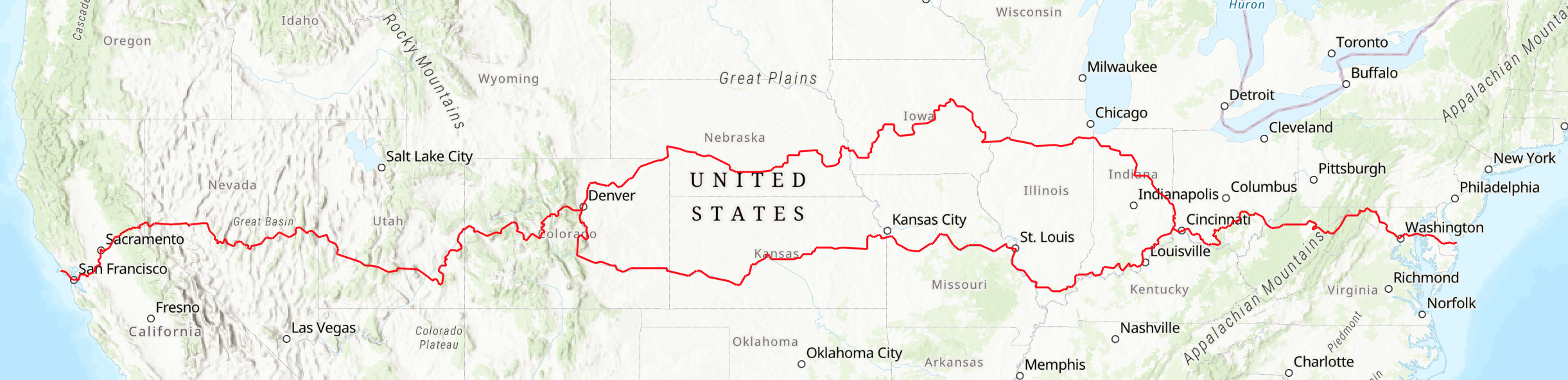
The American Discovery Trail’s Eastern Region stretches from the Atlantic Ocean at Cape Henlopen in Delaware to the southwestern corner of Ohio. This segment crosses Delaware (45 miles), Maryland & Washington, D.C. (271 miles), West Virginia (281 miles), and Ohio (with a short dip into Kentucky) (465 miles). Each section is detailed further below.
This region includes many ecosystems, from beaches and coastal plains to the ridge and valley province of the Appalachians, with eastern forests and farms. Major watersheds include the Chesapeake Bay, the Anacostia River, the Potomac River, and the Ohio River. The trail also passes near historic sites, including the Lincoln Memorial, Arlington National Cemetery, Maryland’s capitol building, the U.S. Naval Academy, and Antietam National Battlefield.
Other points of interest include the first settlement in Delaware, cities such as Cincinnati, and many small historic towns such as Harpers Ferry, West Va. The trail passes through officially designated wilderness areas in West Virginia’s Monongahela National Forest as well as dozens of other state and federal parks and wildlife refuges.
The route is open for hiking, bicycling and other uses permitted by local regulations. Our turn-by-turn directions include bicycle alternates for wilderness areas where bicycles are prohibited and for single-track trails that might be difficult for laden bikes.
The ADT Society has an in-state local coordinator for each of these states. These volunteers are willing to assist hikers, runners, bikers, and other outdoor enthusiasts with the planning of their time on the American Discovery Trail. You can find their contact details on this page.
Delaware
The eastern terminus of the ADT is the Atlantic Ocean: a beach in Delaware. It is appropriate that the ADT begins in the state that was the first to ratify the U.S. Constitution. The beach at Cape Henlopen State Park was the site of a World War II-era U.S. Army fort. Several of the fortifications are still in place, including a bunker that provides an excellent spot for watching ship traffic entering and leaving Delaware Bay. A sign at the bunker marks it as the eastern terminus of the ADT.
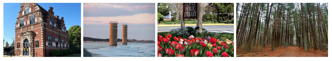
The ADT trail in Delaware travels about 45 miles on bike trails, sidewalks, and rural roads. The trail begins on the beach and pine forest, then passes through the towns of Lewes, Milton, and Bridgeville, which are mostly surrounded by open farmland and state forest lands.
Upon leaving Cape Henlopen State Park you pass the Cape May/Lewes Ferry, which crosses Delaware Bay to Cape May, N.J. The ADT follows the Georgetown-Lewes Trail through Lewes, a growing town of about 2,500 people that is rich in history. Lewes is considered the “first town in the first state” and offers a number of shops, restaurants, and motels. In 1631 Lewes was the site of the first permanent European settlement in Delaware called Zwaanendael, “Valley of the Swans.” Settlers from Holland intended to establish an agricultural and whaling industry, and the settlement is commemorated by the Zwaanendael Museum.
After leaving the Georgetown-Lewes trail, the route follows paved country roads into Milton. This town on the Broadkill River was the shipbuilding capital of Delaware in the 1800s. It contains many fine Victorian mansions. The ADT then follows rural roads through farmland. Soon after crossing U.S. 113, the trail passes through Redden State Forest, which offers primitive camping. While in the forest you pass the watershed boundary between the Atlantic and the Chesapeake Bay. Continuing west, the trail enters Bridgeville, a town of 1,500 people and the agricultural and former railroad center of the region.
The ADT then follows country roads through several unincorporated towns before leaving Delaware on Rural Road 113, which becomes Hobbs Road in Maryland. The boundary between Delaware and Maryland was part of the Mason-Dixon Line.
If you do 45 miles in Delaware, you have done nearly 1% of the coast-to-coast trail.

Maryland and Washington, DC
The 271-mile route through Maryland and Washington includes greenway trails, rural roads, and urban environments. Proceeding west from Delaware the trail passes through small communities on Maryland’s eastern shore. As the ADT continues on to the Chesapeake Bay, it is bordered by inlets and wetlands as it approaches the Kent Narrows Island Greenway. The five-mile long Bay Bridge is the only place on the entire trail where travelers need to arrange a ride.
After crossing the Bay Bridge, the trail enters historic Annapolis, from there the old Washington, Baltimore, and Annapolis rail bed provides an excellent scenic route to Bowie. The ADT then traverses the National Agricultural Center on its way to the historic planned city of Greenbelt. At Greenbelt National Park, you pick up the Anacostia Tributary Trail and then the Fort Circle Trail, which takes you to Rock Creek Park and thence to the C&O Canal National Historic Park in the Georgetown neighborhood of Washington. The canal towpath follows the Potomac River for about 180 miles.
Some Specifics:
Delaware State Line to Chesapeake Bay – 43 miles
The Maryland ADT begins on Hobbs Road in an area known as Ringgolds Green, a former community rich with folklore and ghost stories. The trail soon enters Denton, the county seat of Caroline County. Martinak State Park and privately owned Camp Mardela offer camping.
From Denton the route continues on rural, lightly traveled roads through Ridgely to Tuckahoe State Park. This 1,800-acre park has campsites and a lake for fishing. South of Queenstown is the Wye Island Natural Resource Management Area, a 2,500-acre protected area offering hiking, birding, and water-oriented activities. At Grasonville and Stevensville you have entered Chesapeake Bay country, where you have the choice of many fine seafood restaurants. There are also motels and many fast food options. At Stevensville arrangements must be made for a taxi or a friendly motorist to carry you across the Chesapeake Bay Bridge.
Chesapeake Bay to Greenbelt Park – 42 miles
Annapolis, located on the Severn River just west of the Bay Bridge, is the state capital — the site of Maryland’s Capitol Building, the U.S. Naval Academy, old buildings and a vibrant waterfront. It is a small historic city that has retained its southern character. When it was designated a National Historic Landmark, Interior Secretary Stewart Udall noted that “Annapolis has the greatest concentration of eighteenth-century buildings anywhere in the United States.” Annapolis has always been a maritime center.
The route from Annapolis to Bowie is mostly on two-lane roads south of U.S. 50. Between Bowie and Greenbelt the route goes through the U.S. Department of Agriculture’s Beltsville Agricultural Center, a 7,000-acre working farm with experimental agricultural projects. There are two visitor centers in this area: The USDA National Visitor Center, where you can see examples of various products that were tested here and that are in daily use today, and the U.S. Department of the Interior’s National Wildlife Visitor Center, which has many interactive scientific and environmental exhibits. Greenbelt is one of the first “planned” cities, built in the 1930s during the New Deal. The city got its name from the greenbelt of undeveloped land surrounding the community. A short distance from here is NASA’s Goddard Space Flight Center, which has a visitor center and offers prearranged tours of the facility. Greenbelt Park, a National Park Service unit, offers camping and several hiking trails.
Greenbelt Park to Georgetown, Washington, D.C. – 20 miles
From Greenbelt Park, the route follows the Anacostia stream valley, primarily on a paved off-road trails. At College Park, there are views of the oldest continuously operated airport in the United States, which also has an aviation museum. The Wright brothers and Amelia Earhart flew out of here. Just before entering Bladensburg, the site of a battle in the War of 1812, the route becomes the Northwest Branch Trail into Chillum Park, where you enter Washington at Sixteenth Street. From here, you follow the historic Fort Circle Trail on sidewalks.
During the Civil War, 68 forts encircled the District of Columbia to protect it from Confederate armies. This ring of forts was along Military Road, which the ADT follows. At Thirteenth Street are the partially reconstructed ramparts of Fort Stevens, and at Third Street is a park that was the site of Fort Slocum. Just off Military Road you enter Rock Creek Park, which was laid out by Frederich Law Olmstead, who designed numerous parks across our country. Hikers can follow the blue-blazed trail on the east side of Rock Creek; bikers can use the marked bike trail that parallels Beach Drive.
It is a short detour to visit the National Mall, which is home to the Washington Monument, the Lincoln Memorial, the Smithsonian, and other sites, with a possible side trip across the Potomac River to Arlington National Cemetery and Theodore Roosevelt Island.
Georgetown to Oldtown (C&O Canal Towpath) – 167 miles
This section of the trail is very straight forward: for 167 miles it follows Chesapeake and Ohio (C&O) Canal from Washington to Oldtown. Managed by the National Park Service today, the canal operated from 1850 to 1924. Campsites for hikers and bicyclists are located about every 5 miles beginning at milepost 25 and westward. At Great Falls a boardwalk allows a visit to the very edge of the spectacular falls of the Potomac. Near Harpers Ferry National Historic Park (on the West Virginia side of the Potomac), the Appalachian Trail joins the ADT for about two miles. The Appalachian Trail Conservancy headquarters is in Harpers Ferry. Virginia, West Virginia, and Maryland come together here at the confluence of the Potomac and Shenandoah rivers.
Antietam National Battlefield near milepost 69 was the site of the bloodiest one-day battle of the Civil War. The 3,118-foot-long Paw Paw Tunnel at milepost 156 was the most ambitious and expensive achievement of the canal company. The ADT crosses the Potomac River into West Virginia on a privately owned bridge.
If you do 271 miles in Maryland and DC, you have done about 5% of the coast-to-coast trail.

West Virginia
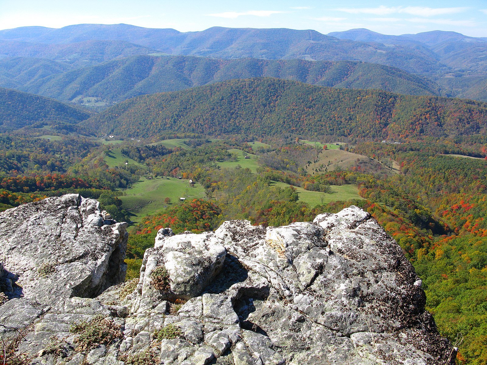
The 281-mile route through West Virginia includes what might be called the “amazement park” of eastern America. The trail offers scenic vistas, pastoral settings, stirring waterfalls, and botanical diversity, while rivers provide for whitewater rafting, kayaking, canoeing and sternwheel pleasures. There are also caves for underground exploring; cliffs for climbing; and friendly people to assure success in your trekking adventures. Plus, the mystique of the Civil War-era tunnels and the local legends of the trail add to West Virginia’s assets for a multifaceted outdoor visit.
The Maryland State Line to Streby – 59 miles
After crossing the Potomac River, the ADT follows a lightly used road to Green Spring. This segment of the ADT follows a valley of the Appalachian mountain range, then crosses a mountain near the Springfield Public Hunting and Fishing Area to Fort Ashby, the small town where George Washington had a fort built in 1755. The ADT also passes the Nancy Hanks Memorial, the birthplace of Abraham Lincoln’s mother. At Greenland Gap, the Nature Conservancy operates a nature preserve. This is part of the Potomac Highlands, some of the oldest mountains and hardwood forests in the world.
Streby to Nestorville – 67 miles
Continuing south on country roads, the ADT passes through the town of Sherr and on to Jordan Run and U.S. Forest Service Road FR 75, which climbs steeply onto the Allegheny Front in Monongahela National Forest. At 3,500 to 4,000 feet, this segment is the highest elevation that the ADT will reach east of the Rockies. The ADT traveler will soon know why West Virginia is called the Mountain State!
The Dolly Sods Wilderness Area is unique in that it resembles the Canadian tundra. It can snow here during any month of the year. This raised plateau provides panoramic vistas of the Allegheny Mountains. The trail then descends to Canaan Valley Resort State Park. The ADT intersects the 311-mile Allegheny Trail at Canaan Valley and follows it to Blackwater Falls State Park. The park gets its name from the five-story-high falls on the Blackwater River where it tumbles down Blackwater Canyon. Still in the Monongahela National Forest, the ADT continues on to Hendricks. Country roads provide the route to Nestorville, through Moatsville to Tygart Lake State Park.
Nestorville to Wilsonburg – 75 miles
This portion of the trail includes Grafton and the International Mother’s Day Shrine, which was the site of the first observance of Mother’s Day on May 10, 1908. The route takes country roads to Spetler, where it picks up the Harrison County Rail-Trail to Clarksburg. Clarksburg is the birthplace of General Thomas J. “Stonewall” Jackson. Over 40 percent of the town is of Italian descent and each Labor Day the West Virginia Italian Heritage Festival is held here.
Wilsonburg to Ohio State Line – 80 miles
From Wolf Summit for the next 60 miles to Walker, the ADT follows the North Bend Rail-Trail, a National Recreation Trail, through one mountain valley after another. Managed as part of North Bend State Park, this trail has 10 tunnels and 37 trestles. There are several points of interest, including New Fort Salem at Salem, the Old Stone House at Pennsboro, and the glass industry in Pennsboro and Ellenboro, where marbles and hand-blown glassware are made. Ritchie County is famous for its asphalt mines, which produced the material for many of Europe’s first paved roads. Remnants of gas and oil fields dot the way. At Parkersburg, a side trip to Blennerhasset Island Historical State Park by a stern-wheeler is worthwhile. Harman Blennerhassett built a mansion here in 1800 and allegedly plotted with Aaron Burr to establish an independent southwest empire. The ADT enters Ohio by crossing the U.S. 50 bridge over the Ohio River to Belpre.
If you do 281 miles across West Virginia, you have done about 5% of the coast-to-coast trail.

Ohio and Kentucky
The ADT route in Ohio is 465 miles long, on trails through public lands, on public ways, and occasionally on private lands with landowner permission. Our description below splits it into eleven sections.
In 1803, Ohio was the first state to be carved out of the Northwest Territory. The Europeans who settled this region found hardwood forests that covered 95 percent of the land. Much of southern Ohio through which the ADT runs is still heavily wooded. The Appalachian Plateau in eastern Ohio has narrow valleys, steep hills, and many caves. The American Discovery Trail follows the Buckeye Trail for most of its route through Ohio from Chester Hill to Eden Park in Cincinnati. The 1,445-mile Buckeye Trail is unique because it is the only trail that completely circles the state through which it runs. The route uses the least-traveled rural roads possible to connect off-road sections. The trail is marked with blue blazes for the Buckeye Trail section and ADT markers for connections to West Virginia and Indiana.
Belpre to Chesterhill — 34 miles
The ADT crosses the Ohio River using the Parkersburg-Belpre Bridge, passes through Blennerhassett Park, and takes little-used back roads past Veto Lake to Vincent, Layman, and Chester Hill, where it joins the Buckeye Trail.
Chesterhill (begin Buckeye trail) to East Branch Church Road/SR 78— 16 miles
Following paved and gravel roads, the ADT passes through the southern part of Wolf Creek State Wildlife Area.
East Branch Church Road/SR 78 to Ohio SR 664 — 57 miles
The trail goes through Burr Oak State Park to Tom Jenkins Dam and then enters Wayne National Forest, which was named for Revolutionary War hero General Anthony Wayne. The trail traverses Trimble State Wildlife Area and re-enters Wayne National Forest on some of the national forest’s 200 miles of trails, passing Lake Tecumsey south of the town of Shawnee.
Ohio SR 664 to SR 327 — 45 miles
The ADT passes through Webb Summit and enters the region of the Hocking Hills, an area of Black Hand sandstone hills, cliffs, and caves. This area of eroding sandstone was formed during the late Mississippian geological era when this was the shore of an ancient sea. Passing north of the town of Logan, the ADT connects the Cedar Falls, Old Man’s Cave, and Ash Cave units of Hocking Hills State Park.
Ohio SR 327 to Pike Lake State Park — 62 miles
The route heads southwest through Tar Hollow State Forest east of Chillicothe, Ohio’s first state capital, and on to Scioto Trail State Park and State Forest; the towns of Alma, Denver, and Nipgen; and Pike Lake State Park and State Forest.
Pike Lake State Park to Davis Memorial State Nature Preserve — 56 miles
Near Sinking Spring, the ADT follows trails through Fort Hill State Memorial and Nature Preserve, the site of a prehistoric earthwork enclosing 48 acres believed to have been built by the Hopewell Indians. Now heading south, the trail passes through Buckeye Trail property and enters the Serpent Mound Historic Site, the largest and finest serpent effigy in North America, and enters the community of Marble Furnace. Near Marble Furnace, the trail passes historic Wickerham Tavern, which was a stop for runaway slaves on the Underground Railroad. Davis Memorial Nature Preserve is 88 acres of rugged dolomite cliffs and rock towers northeast of West Union that the ADT passes through before circling near the east side of Mineral Springs Lake.
Davis Memorial to Long Lick & Sunshine Ridge Roads — 43 miles
This part of Ohio is known as the “Little Smokies” because of its resemblance to the Great Smokies. The hills are steep, but the scale is smaller. The ADT follows the Buckeye Trail crossing, Shawnee State Forest and Shawnee State Park on rugged footpaths in some of Ohio’s steepest topography.
Long Lick & Sunshine Ridge Roads to Grant Lake — 62 miles
The trail follows little used roads in a sparsely settled wooded landscape through the villages of Bentonville, Neel, and New Hope. It fords Sterling Run twice before reaching Grant Lake.
Grant Lake to Eden Park, Cincinnati — 64 miles
The ADT goes along Grant Lake near Mount Orab, then over the East Fork of the Little Miami River into Williamsburg. Twenty eight miles of the Buckeye Trail are in East Fork State Park with its 2,160-acre lake. After going through the small town of Batavia, the ADT enters Milford, a suburb of Cincinnati and takes on a definite urban character after going under I-275. From Milford to Krugerhill, the ADT follows an abandoned railbed along the Little Miami River.
The town of Mariemont is a planned community founded in 1923 and is on the National Register of Historic Places. From the village of Fairfax, the ADT and Buckeye Trail are mostly on sidewalks into Eden Park, where the two trails split. Eden Park offers splendid views from high above the Ohio River, which allow you to see well into Kentucky.
Eden Park, Cincinnati to Elizabethtown including some miles in Kentucky — 28 miles
On sidewalks through Mount Adams, a historic part of Cincinnati, the ADT heads downhill to the Bicentennial Commons. The South Western Ohio Trails Association mounted a bronze plaque at Yeatman’s Cove recognizing the American Discovery Trail in Cincinnati. The ADT also passes the famous statue of the Flying Pigs and Riverfront Stadium and crosses the Roebling Suspension Bridge into Covington, Ky.
Covington experienced a major influx of German immigrants in the 1840s. Their history is preserved in an area known as MainStrasse. A steep climb up cement steps takes the ADT to Devou Park, where there are outstanding views of Covington and downtown Cincinnati. After re-crossing the Ohio River on the historic Anderson Ferry, the ADT is back in Ohio. The trail passes the tomb of President William Henry Harrison as it follows close to the Ohio River.
If you do the above 465 miles in Ohio and Kentucky, you have done about than 10% of the coast-to-coast trail. At Elizabethtown, the path divides into a southern route and a northern route through the Midwest, which re-unite in Denver. The southern route passes into Indiana in about a mile. The ADT northern route includes an additional 59 miles in Ohio.
Two Options at Elizabethtown:
Elizabethtown to the Pacific - via the ADT Southern Route — 3,936 miles
Elizabethtown to the Pacific - via the ADT Northern Route — 3,782 miles